The Impact of Environmental Hazards on Solar Project Development


From unmapped toxic spill sites and orphan oil wells to severe pluvial flooding and localized seismic activity, environmental blind spots destroy project economics faster than interconnection bottlenecks. A single overlooked constraint can trigger cascading redesigns, failed environmental site assessments, inflated insurance premiums, or outright site abandonment after months of capital investment.
Below, we walk through how environmental hazards affect solar projects at each stage of development, and what developers should be evaluating at each one.
Why Early Environmental Hazard Screening Matters
When evaluating prospective acreage, skipping granular environmental due diligence creates risk vectors across every phase of the project lifecycle:
Capital Wasted on Flawed Acreage: Executing land option agreements and paying thousands of dollars for formal Phase I ESAs on sites with Superfund overlays, severe slope issues, or undocumented underground storage tanks (USTs) burns critical capital.
Layout & Capacity Reduction: Discovering floodplains or abandoned oil and gas wells late in the planning cycle shrinks your buildable footprint. What was slated as a 100 MWac facility can quickly shrink to 60 MWac once proper setbacks, buffers, and unbuildable zones are carved out.
Increased Balance-of-System (BOS) & Insurance Costs: Developing in moderate-to-high risk zones for hail, extreme wind, or severe flooding requires costlier structural engineering: taller tracker piles, reinforced mounting, automated stowing systems, and specialized drainage infrastructure. Without early risk detection, insurers may double liability premiums or refuse coverage altogether.
M&A and Offtake Liabilities: For developers looking to flip assets or secure long-term PPA agreements, unquantified climate or environmental hazards represent massive valuation discounts during buyer due diligence.
Overall, unforeseen hazards can cause major project delays. Redesigns, new permits, and additional land acquisition can push back completion dates. Combined with already lengthy site-specific due diligence, these hazards create bottlenecks that slow initial evaluations and the entire development pipeline.
Lifecycle View of The Impact of Environmental Hazards on Solar Project Development
The cost of an environmental problem depends less on the problem itself than on when you find it. The sections below show how that cost curve plays out at each stage.
Stage 1: Site Screening - Hazards Determine What’s Actually Buildable
Effective screening starts wide and narrows fast. At the regional level, hazard heatmaps show where severe-weather, seismic, or contamination exposure is concentrated, so origination teams can steer toward lower-risk counties before a single landowner call.

At the parcel level, the question becomes net buildable acreage: what remains after flood zones, wetlands, waterways and their buffers, oil and gas wells and their setbacks, and slopes beyond what your racking system can tolerate.
Two details make this harder than it sounds. First, exclusion distances aren't uniform. Well setbacks, wetland buffers, and stream buffers vary by state and county, so the same parcel can net very different acreage depending on jurisdiction. Second, constraints interact. A parcel can clear every individual exclusion and still be fragmented into pieces too small or irregular for an efficient layout. Screening on contiguous buildable area, not just total buildable acres, avoids that trap.
LandGate maps these exclusions nationwide for regional screening. For shortlisted parcels, developers can build a Solar Analysis project that applies the exclusions at the parcel level and layers in custom exclusions and setbacks to match local requirements, so the modeled layout reflects the jurisdiction the project will actually be permitted in.

Stage 2: Due Diligence - What a Pre-Phase I Screen Should Catch
Before committing to a formal Phase I ESA, developers should run a pre-Phase I screen that looks beyond the parcel boundary. Three categories deserve particular attention:
Legacy oil and gas wells. LandGate’s data shows over 2.4M abandoned wells in the US. Even properly plugged wells carry setback and access requirements, and an orphaned well can raise methane and brine questions that stall a closing.
Off-site contamination. A Superfund site, toxic spill, or leaking UST on a neighboring property can affect soil and groundwater beneath yours. Proximity matters, not just presence on the parcel itself.
Induced seismicity. Wastewater injection from oil and gas operations has created earthquake exposure in parts of Oklahoma and Texas that historical seismic maps never flagged. That exposure belongs in foundation design and long-term structural assumptions.
A clean pre-Phase I screen doesn't replace the formal assessment; lenders and CERCLA liability protections still depend on it. But it means that the Phase I is confirming a good site rather than discovering a bad one. And contamination isn't automatically disqualifying. Brownfields can make strong solar sites when the issues are known and priced in from the start.
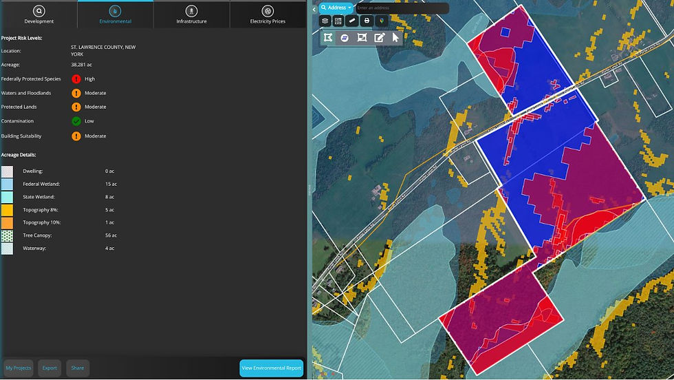
LandGate acts as a Pre-Phase 1 Environmental Assessment filter within its automated Environmental Reports. By aggregating historical contamination logs, state UST registries, abandoned well locations, and environmental hazard overlays into a single report, developers can conduct a preliminary environmental screening in seconds.
Stage 3: Financing & Capital Markers - De-Risking the Asset for Underwriters
By the time a project reaches tax equity, debt syndication, or off taker negotiation, environmental hazard evaluation shifts from site layout to capital cost and insurability. As projects scale up, tax equity investors and lenders are requiring higher coverage limits, and carriers are pricing risk site by site. A developer who can present parcel-level scores across hail, tornado, straight-line wind, hurricane, wildfire, and flood, along with the design measures that respond to each, negotiates from a far stronger position than one relying on regional averages.
Hazard data is most persuasive when it connects to the numbers lenders actually underwrite. LandGate's automated Solar Economic Reports within the Solar Analysis tool model a project's capital and operating costs, revenue, and risk-adjusted net asset value, with insurance and structural balance of the system broken out as separate line items. LandGate’s Solar Pro Forma Reports go a step further, laying out year-by-year cash flow and debt service coverage ratio (DSCR) over the project's life.

Stage 4: Operations & M&A - Protecting Asset Yield & Exit Valuations
The final impact of environmental hazards occurs during long-term operations or asset sales. Whether holding the asset for 35 years or flipping it at Commercial Operation Date (COD), physical hazards directly govern asset valuation.
Catastrophic events get the headlines, but chronic exposure quietly erodes performance over an asset's life. Drought increases soiling and cleaning water demand while drying out vegetation, which raises wildfire risk: two hazards compounding each other. Repeated flooding undermines foundations and cuts off site access for O&M crews. Sub-catastrophic hail and wind events chip away at production without ever triggering a claim.
Mitigation works best when it's designed into the process rather than retrofitted. An effective hail stow protocol, for example, can reduce potential hail losses on a typical utility-scale project from more than $50 million to under $5 million. Fire breaks, vegetation management plans, elevated equipment pads, and drainage systems are likewise cheapest when planned before construction. That's why hazard data gathered at screening should carry through to engineering and O&M planning, not sit in a diligence file.
How to Evaluate Environmental Hazards for Every Stage of Solar Project Development with LandGate
The common thread across all four stages is that environmental risk is cheapest to address early and most expensive to discover late. That requires data that is comprehensive, parcel-specific, and available at screening, not only after a developer commits to expensive studies.
LandGate’s solar due diligence tools bring that full picture together in one platform:
Parcel build exclusions. Flood zones, wetlands, waterways, oil and gas wells, and topography are mapped nationwide. In a Solar Analysis project, developers can apply these at the parcel level and add custom exclusions and setbacks to model buildable acreage under local rules.
Contamination layers. Abandoned wells, Superfund sites, toxic spill sites, and underground storage tanks are mapped so developers can spot legacy liabilities before signing a lease or option.
Risk Index Scores. LandGate's proprietary models score every parcel from 0 to 100 across 11 hazard categories: Oil & Gas Contamination, Industrial Contamination, Drought, Wildfire, Natural Earthquakes, Induced Earthquakes, Hurricane, Tornado, Straight Line Wind, Hail, and Flood. Scores can be viewed as a heatmap for regional screening or pulled for individual parcels during diligence.
Environmental reports in the Solar Analysis tool. Think of these as a pre-Phase I assessment. Before investing in a formal Phase I ESA, developers can generate a parcel-level environmental report in minutes that consolidates build exclusions, nearby contamination, and Risk Index Scores into a single document. Sites with red flags can be dropped or priced accordingly. Sites that come back clean move forward to a formal Phase I with fewer surprises. The report is also easy to share with internal teams, landowners, lenders, and insurers.
Because climate, contamination, and geologic risks live side by side, solar developers don't have to stitch together separate datasets to see whether a parcel's biggest problem is hail, a forgotten well, or a floodplain. And because the same data supports screening, diligence, and financing conversations, the risk picture stays consistent from the first map view to financial close.